# E:earth_africa:dal Earth Observation Data Analysis Library
**A truely open-source package for unified analysis of Earth Observation (EO) data**
:heavy_check_mark: Cloud-native by design thanks to [STAC](https://stacspec.org/en)
:heavy_check_mark: Access to Petabytes of global EO data including satellite imagery with native `Mapper` module
:heavy_check_mark: EO data querying, I/O, processing, analysis and visualization in a single package
:heavy_check_mark: Modulare and lightweight architecture
:heavy_check_mark: Almost unlimited expandability with interfaces to [xarray](https://docs.xarray.dev/en/stable/), [numpy](https://numpy.org/), [geopandas](https://geopandas.org/en/stable/), and many more
## About
E:earth_africa:dal is a Python library enabling the acquisition, organization, and analysis of EO data in a completely open-source manner within a unified framework.
E:earth_africa:dal enables open-source, reproducible geo-spatial data science. At the same time, E:earth_africa:dal lowers the burden of data handling and provides access to **global satellite data archives** through **downloaders** and the fantastic **SpatioTemporalAssetsCatalogs** (STAC).
E:earth_africa:dal supports working in **cloud-environments** using [STAC catalogs](https://stacspec.org/) ("online" mode) and on **local premises** using a spatial PostgreSQL/PostGIS database to organize metadata ("offline" mode).
Read more about E:earth_africa:dal in [our peer reviewed article](https://doi.org/10.1016/j.compag.2022.107487).
## Citing E:earth_africa:dal
We put a lot of effort in developing E:earth_africa:dal. To give us proper credit please respect our [license agreement](LICENSE). When you use E:earth_africa:dal for your **research** please [**cite our paper**](https://doi.org/10.1016/j.compag.2022.107487) in addition to give us proper scientific credit.
```latex
@article{GRAF2022107487,
title = {EOdal: An open-source Python package for large-scale agroecological research using Earth Observation and gridded environmental data},
journal = {Computers and Electronics in Agriculture},
volume = {203},
pages = {107487},
year = {2022},
issn = {0168-1699},
doi = {https://doi.org/10.1016/j.compag.2022.107487},
url = {https://www.sciencedirect.com/science/article/pii/S0168169922007955},
author = {Lukas Valentin Graf and Gregor Perich and Helge Aasen},
keywords = {Satellite data, Python, Open-source, Earth Observation, Ecophysiology}
}
```
## Data Model
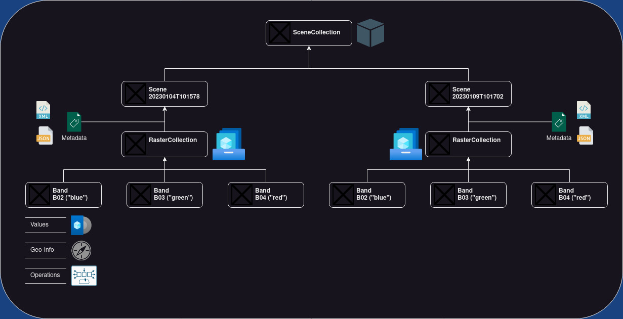
E:earth_africa:dal has a sophisticated data model projecting the complexity of Earth Observation data into Python classes. The object-based design of E:earth_africa:dal has four base classes:
* [E:earth_africa:dal Band](https://github.com/EOA-team/eodal/tree/master/eodal/core/band.py) is the class for handling single bands. A band is a two-dimensional raster layer (i.e., an two-dimensional array). Each raster cell takes a value. These values could represent color intensity, elevation above mean sea level, or temperature readings, to name just a few examples. A band has a name and an optional alias. Its raster grid cells are geo-referenced meaning each cell can be localized in a spatial reference system.
* [E:earth_africa:dal RasterCollection](https://github.com/EOA-team/eodal/tree/master/eodal/core/raster.py) is a class that contains 0 to *n* Band objects. The bands are identified by their names or alias (if available).
* [E:earth_africa:dal Scene](https://github.com/EOA-team/eodal/tree/master/eodal/core/raster.py) is essential a RasterCollection with `SceneMetadata` assigning the RasterCollection a time-stamp and an optional scene identifier.
* [E:earth_africa:dal SceneCollection](https://github.com/EOA-team/eodal/tree/master/eodal/core/raster.py) is a collection of 0 to *n* Scenes. The scenes are identified by their timestamp or scene identifier (if available).
## Mapper
The E:earth_africa:dal [Mapper](https://github.com/EOA-team/eodal/tree/master/eodal/mapper/mapper.py) is one of the key components of E:earth_africa:dal. If you are familiar with [GEE](https://earthengine.google.com/) you can expect a similar easy access to vast amounts of EO data - except that is truely open-source. If you are absolutely new to EO you will quickly learn how to query, read and process large data volumes.
In the example below Sentinel-2 data is loaded for an area-of-interest in central Switzerland from [Microsoft Planetary Computer](https://planetarycomputer.microsoft.com/) (no authentication required).
```python
import geopandas as gpd
from datetime import datetime
from eodal.core.sensors.sentinel2 import Sentinel2
from eodal.mapper.feature import Feature
from eodal.mapper.filter import Filter
from eodal.mapper.mapper import Mapper, MapperConfigs
from typing import List
#%% user-inputs
# -------------------------- Collection -------------------------------
collection: str = 'sentinel2-msi'
# ------------------------- Time Range ---------------------------------
time_start: datetime = datetime(2022,3,1) # year, month, day (incl.)
time_end: datetime = datetime(2022,6,30) # year, month, day (incl.)
# ---------------------- Spatial Feature ------------------------------
geom: Path = Path('data/sample_polygons/lake_lucerne.gpkg')
# ------------------------- Metadata Filters ---------------------------
metadata_filters: List[Filter] = [
Filter('cloudy_pixel_percentage','<', 80),
Filter('processing_level', '==', 'Level-2A')
]
#%% query the scenes available (no I/O of scenes, this only fetches metadata)
feature = Feature.from_geoseries(gpd.read_file(geom).geometry)
mapper_configs = MapperConfigs(
collection=collection,
time_start=time_start,
time_end=time_end,
feature=feature,
metadata_filters=metadata_filters
)
# now, a new Mapper instance is created
mapper = Mapper(mapper_configs)
mapper.query_scenes()
#%% load the scenes available from STAC (reading bands B02 "blue", B03 "green", B04 "red")
scene_kwargs = {
'scene_constructor': Sentinel2.from_safe,
'scene_constructor_kwargs': {'band_selection': ['B02', 'B03', 'B04']}
}
mapper.load_scenes(scene_kwargs=scene_kwargs)
# the data loaded into `mapper.data` as a EOdal SceneCollection
mapper.data
```
## Examples
We have compiled a set of [Jupyter notebooks](https://github.com/EOA-team/eodal_notebooks) showing you the capabilities of E:earth_africa:dal and how to unlock them.
## Contributing
Contributions to E:earth_africa:dal are welcome. Please make sure to read the [contribution guidelines](https://github.com/EOA-team/eodal/tree/master/Contributing.rst) first.


